


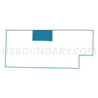
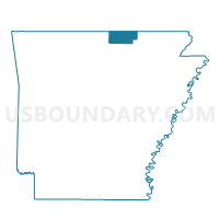
Washington Voting District, Fulton County, Arkansas
About
Outline

Summary
| Unique Area Identifier | 526492 |
| Name | Washington Voting District |
| County | Fulton County |
| State | Arkansas |
| Area (square miles) | 40.41 |
| Land Area (square miles) | 40.39 |
| Water Area (square miles) | 0.01 |
| % of Land Area | 99.97 |
| % of Water Area | 0.03 |
| Latitude of the Internal Point | 36.46379900 |
| Longtitude of the Internal Point | -91.86579220 |
Maps

Graphs
Select a template below for downloading or customizing gragh for Washington Voting District, Fulton County, Arkansas


Neighbors
Neighoring Voting District (by Name) Neighboring Voting District on the Map
- Benton Voting District, Fulton County, AR
- Calm Voting District, Fulton County, AR
- Fulton Voting District, Fulton County, AR
- Myatt Voting District, Howell County, MO
- South Fork Voting District, Fulton County, AR
- South Fork Voting District, Howell County, MO
- Wilson Voting District, Fulton County, AR
Top 10 Neighboring County Subdivision (by Population) Neighboring County Subdivision on the Map
- Benton township, Fulton County, AR (2,564)
- South Fork township, Howell County, MO (1,109)
- Fulton township, Fulton County, AR (1,049)
- Myatt township, Howell County, MO (655)
- South Fork township, Fulton County, AR (485)
- Washington township, Fulton County, AR (406)
- Wilson township, Fulton County, AR (278)
- Mount Calm township, Fulton County, AR (207)
Top 10 Neighboring Elementary School District (by Population) Neighboring Elementary School District on the Map
Top 10 Neighboring Unified School District (by Population) Neighboring Unified School District on the Map
- West Plains R-VII School District, MO (13,461)
- Salem School District, AR (4,684)
- Viola School District, AR (3,223)
Top 10 Neighboring State Legislative District Lower Chamber (by Population) Neighboring State Legislative District Lower Chamber on the Map
Top 10 Neighboring State Legislative District Upper Chamber (by Population) Neighboring State Legislative District Upper Chamber on the Map
Top 10 Neighboring 111th Congressional District (by Population) Neighboring 111th Congressional District on the Map
Top 10 Neighboring Census Tract (by Population) Neighboring Census Tract on the Map
- Census Tract 5502, Fulton County, AR (6,287)
- Census Tract 906, Howell County, MO (5,182)
- Census Tract 904, Howell County, MO (4,849)